Cross-country walking
Off-track?
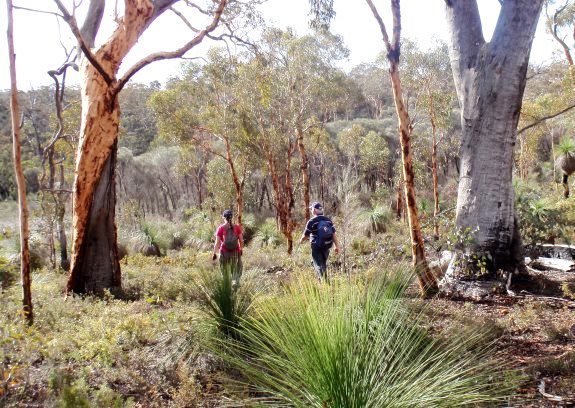
‘Off-track’ walking (i.e. cross-country; not on existing paths or marked trails) in often-remote areas is a hiking tradition not unique to this state or globally. Long before WalkGPS, in 1985 Meney & Brown’s “Forests on Foot – 40 walks…” highlighted the suitability of our parks and state forests for off-track bushwalking. In W.A. conditions, including the Perth region’s open jarrah forests and wandoo woodlands, the walkers’ activities are minimum impact and environmentally sustainable.
Why?
A key attraction of an unmarked route or walking corridor for many bushwalkers is the very fact that it is unmarked, enhancing the sense of freedom, exploration, adventure, risk and/or challenge. Others may simply be seeking the heightened appreciation of wilderness that comes with greater solitude, away from the often busy, developed trails.
WalkGPS walks
Many of the WalkGPS walk routes are either mainly off-track or have a significant off-track component. The off-track sections have been selected for walking enjoyment. But be prepared for surprises; the Australian bush is ever-changing. An initially easy, open forest walk – over a period of just a few years following a bushfire – may turn into a grim struggle through a new dense understorey of ‘Prickly Moses’!
Navigation skills
Aside from always carrying a map and compass and knowing how to use both, proficient GPS-user skills are recommended if you wish to follow the WalkGPS routes closely; the waypoints have been designed for GPS-users rather than for traditional compass navigation. A compass should always be carried as a standby, but preferably not used as the primary navigation tool as many of the waypoints and features are not distinctive landmarks; they could be missed very easily using map and compass alone.
The easiest walking between each pair of waypoints along a suggested walk route is seldom along the most direct, straight line course. When walking off-track, you need to be prepared to pick your own sensible route to the next waypoint by looking ahead and varying from a direct line to bypass local obstacles such as patches of denser, scratchy vegetation.
Map & Compass?
If you prefer traditional compass navigation, the maps on this site should still be useful to experienced bushwalkers. You can easily adapt and simplify several of the walks yourself from the maps to make them more suited to compass work (remembering to add approx. 2 degrees to grid north bearings read from the maps to correct them to current magnetic north).