Walks & Parks
 Bibbulmun Track – See Bibbulmun Track Foundation website for track guide books and Day Walk Map Packs including The Darling Range pack and a Dwellingup pack. See Trails WA for KML file.
“Bushwalks of the Perth Region – 40 Adventurous Day Walks“, Dave Osborne, 2025. WalkGPS. (ISBN 978-0-646-71674-9).
“Family Walks in Perth Outdoors“, CALM, revised edn. 2005.(ISBN 978-0-7307-5505-0).
“More Family Walks in Perth Outdoors“, CALM, revised edn. 2005. (ISBN 978-0-7307-55555).
“Forests on Foot – 40 walks in the forests of the South West of Western Australia”, Kathy Meney, & P. Brown, 1985. The Campaign to Save Native Forests. (ISBN 0 9589269 0 5). Still a wonderful little book though dated, partly due to mining impacts and loss of access to some areas. Can be viewed at State Library of WA (book Call Ref. # 919.412 MEN).
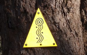
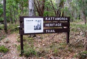 Kattamorda Heritage Trail – This 27 (-29)km trail (initial spelling ‘Kattamordo’ later revised to ‘Kattamorda’) was initiated by Heritage Council of Western Australia in 1998. It fell into disrepair and was partly taken over by mountain bike users, but was partly re-aligned and re-instated for trail runners and bushwalkers by the Friends of Kattamorda Heritage Trail during 2020-2022. (See here for Maps / GPX /KML files). The Heritage Council’s 22-page pamphlet (out-of-print) provides an overview of the interesting history along the original trail (and the Mason & Bird Heritage Trail). Pickering Brook – Mt Gunjin and Pickering Brook –shorter version. Walks on WalkGPS include parts of the old trail.
Kep Track – This 75km multi-use trail (walk, cycle, horse-ride) follows the rail reserve, from near Mundaring Weir to Northam. It forms part of NTWA’s Golden Pipeline Project to commemorate the Kalgoorlie water supply pipeline built in the 1890’s. See Trails WA for KML file.
Kings Park & Bold Park – Kings Park & Botanic Garden site; includes path maps. Kings Park offers near-city centre walking across its 406ha area of bushland, parkland and gardens. Short Kings Park walks include the Botanic Garden Discovery Walk (less than 2.5km) or pick out your own interesting circuit walk routes of 9-10km along the many paths; especially worthwhile in the wildflower season. Also see WalkGPS suggested 9km Bold Park walk route.
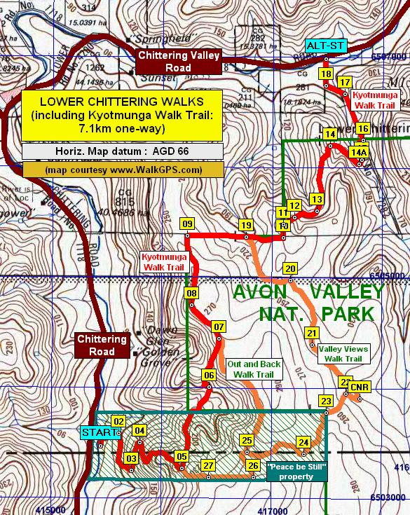
 Kyotmunga Walk Trail – A 7km point-to-point trail; access in south from “Peace Be Still” private car park off Chittering Rd, and in north from Yozzi Rd off Chittering Valley Rd (initial section is signed as ‘W’ trail through citrus orchard). Lies mainly within the NW-most area of Avon Valley National Park. Regarded as one of the best on-track trails in the Shire of Chittering. Passes partly through wandoo woodlands and provides views across Chittering Valley. See WalkGPS map including other Lower Chittering area trails. If planning to walk this trail, walkers should phone “Peace Be Still” in advance to check the front gate to the carpark will be unlocked. NOTE: In mid-2023 the trail was to be temporarily closed at the northern end while the Shire did some trail upgrade work. The trail from Yozzi Rd end is on public space / easement where it passes through the private property. Unfortunately a large section of the trail, within Avon Valley National Park, is not being maintained by DBCA Parks and Wildlife, so is becoming quite overgrown.
Metropolitan area dual pathways – See Cycling Maps (Department of Transport). Many of the cycle ways around the Swan and Canning Rivers within the Perth metropolitan area are ‘shared paths’. Although these are not ‘bushwalks’ they provide a pleasant way to keep walking-fit in the summer months when it’s otherwise too hot for bushwalking.
 Munda Biddi (Bike) Trail – The 1000km Munda Biddi Trail from Mundaring to Albany is intended mainly for off-road cyclists, but walkers are also accepted. See DBCA for online ordering of maps and Trails WA for KML file.
Parks & Wildlife Service – Park Finder – Search by selecting Region (Australia’s Southwest) and Activities > Bushwalking.
Paruna Sanctuary – A beautiful 2000ha sanctuary, run by Australian Wildlife Conservancy. Located between the Walyunga and Avon Valley National Parks. Includes some of the best on-track walking in the Perth region, including the Numbat Trail (12 km), Quenda Circuit (6.5 km), and Possum Loop (2.3 km). Visits need to be pre- arranged. Trail notes (with maps) are available just inside the entrance gate. Small entry fee. Park closed to bushwalkers during bushfire season (1 December – 31 March). See Trails WA site for KML file for Numbat Trail.
“Perth’s Best Bush, Coast and City Walks”, Paul Aymes, July 2010. Woodslane, NSW, (ISBN 9781 9216 06793). For 40(+) leisurely short walks on paths in and around Perth (including Darling Range).
Railway Reserves Heritage Trail – This multi-use trail (walk, cycle, horse-ride) in Shire of Mundaring retraces 59km of the old Eastern Railway which once linked Fremantle to York in the late 1880s. The trail begins at Bellevue (near Midland), with a choice of north (19km) and south (21.6km) branches which rejoin at Mt Helena. The trail then continues for 18km via Chidlow to end at Wooroloo. See Trails WA site for KML file.
“Swan Valley and Perth Hills Trails Discovery Guide”, Eastern Metropolitan Regional Council (EMRC). 2005. (ISBN 0-9757364-0-X). -This was an excellent, though short-lived booklet with good maps and trail notes for 41 mainly short, existing trails in Shires of Kalamunda and Mundaring and City of Swan. Unfortunately it was quickly withdrawn from public sale. A copy can still be located by the very determined at the State Library of WA (book Call Ref. # 919.411 SWA).
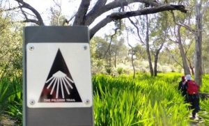 The Pilgrim Trail / Camino Salvado – A 185km, 7-day walk from St Joseph’s Church, Subiaco to the Benedectine Monastery in New Norcia. See Trails WA for KML file.
Trails WA –About 30 mainly short walk trails on Trails WA fall within the the Darling Range portion of the Perth region. Some of the longer walks include the popular, established Eagle’s View (John Forrest NP), Kittys Gorge (Serpentine NP), and King Jarrah Trails (Lane Poole Reserve). These latter trails also feature in walks on WalkGPS.
Walks and Parks of Jarrahdale – Jarrahdale Heritage Society. For local trail maps in Jarrahdale area, including Stacey’s Track and Kitty’s Gorge Trails).
WalkGPS Blog article “A late spring in the step” (Oct. 2010) – Provides an outline of about 10 good short bushwalking ideas for warm weather.
WalkGPS bushwalks – For over 80 good circuit bushwalks in the Perth region on this site.
Whiteman Park Recreation & Conservation Reserve trails – The short walk/bike trails through bushland and wetlands of this 4200ha (over 10,000 acres) park less than 20km from Perth city include the Goo Loorto (3km return), Wunanga (4.3km loop) and Werrillyiup (2.5km loop) Trails.
Yalgorup National Park walks– See Wildflower walks in Peel Region, Mandurah Wildflower Group site for downloadable brochures for Heathland Walk (4.5 km) and at Estuary Walk (6 km). See Trails WA site for Lake Pollard Walk (6km) including KML file. The Martins Tank Camping Ground lies on the western side of Martins Tank Lake. See DBCA’s site for general info. on the National Park. Also Yalgorup National Park Management Plan #29 1995-2005 has summaries of the flora & fauna, geology, history, etc.
Yanchep National Park walks – See DBCA’s site for general info. on the National Park. Also Parks & reserves of Yanchep and Neerabup Management Plan #76 (2012) The Plan has summaries of the flora & fauna, geology, history, future park plans, etc. The Park includes the following walk trails:
Cockatoo Trail 17.5km circuit. See Trails WA for overview and KML file and overview.
 Coastal Plain Trail 55 km (3-day) trail between Yanchep NP and Neaves Rd, with 3 overnight campsites. See Trails WA for overview and KML file.
Ghost House Trail 12.5km circuit. See Trails WA for overview and KML file and overview.
Yaberoo Budjara Heritage Trail 28km point-to-point trail. See Trails WA for KML file.
Yanchep Rose Trail 14km circuit. See Trails WA site for overview and KML file and overview.
“Adventurous Walks in WA’s South West“, Dave Osborne, 2025. WalkGPS. (ISBN 978-0-646-72263-4).
Cape to Cape Track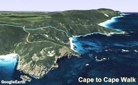 (Friends of Cape to Cape Track)- Guide book and maps cover the 5-7 day,135km track plus linked 13.5km Meelup Reserve Trail and many suggested short walks. Subscribers to WalkGPS are welcome to contact WalkGPS to receive GPX file (track plus waypoints); available only to subscribers. Also see Trails WA site for KML files including for Meelup Reserve Trail. Also see “Boranup-karri forest to beach” (WalkGPS video).
Parks & Wildlife Service – Park Finder – Search by selecting Activities > Bushwalking.
Walking the Southwest Corner – From the Photodiary of a Nomad. Inspiring accounts and splendid photos from 380km of tracks walked in the southwest, including Cape to Cape Track, Bibbulmun Track (section from Walpole to Albany), and several day walks in the Stirling Range and Cape Le Grand National Parks.
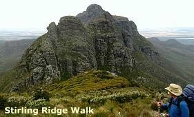 Stirling Ridge Walk – An indispensable guide book for this challenging 2-3 day walk in Stirling Range National Park is “Mountain Walks in the Stirling Range, Part 2, The peaks to the east of Chester Pass“, A.T. Morphet, 1996, Torridon Publications, Capel, W.A.,; ISBN 0 646 29139 4); but now out of print. The Stirling Ridge Walk can be a gruelling one, over some arduous mountainous terrain; but it also offers a truly supreme bushwalking opportunity not to be missed by any experienced, hardy walker. View Joey Curry’s Relive! videos of a west to east traverse in 2018 (best on full screen): Day 1 / Day 2 / Day 3. Also see ‘davidandlenah’ trail notes and photos, and videos from wwwruffridetk and scottyakamentalfocus. Subscribers to WalkGPS are welcome to contact WalkGPS to receive additional information on the walk (available only to subscribers).
Other Stirling Range walks – Aside from the Ridge Walk, Stirling Range N.P. offers many other outstanding day walks. Morphet’s other 1996 guide book “Mountain Walks in the Stirling Range, Part 1, The peaks to the west of Chester Pass“ (ISBN 0 646 29138 6) is also excellent. Some walks are becoming closed to walkers due to the spread of Dieback disease within the Park. Also see Trails WA site for KML files for the Bluff Knoll, Mount Toolbrunup and Talyuberlup walk trails.
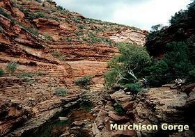 Kalbarri National Park – DBCA provides general information (including map) and mention of walking opportunities in the Park, located about 550km north of Perth. The Murchison Gorge offers the fit and experienced walker some more adventurous ‘off-track’ walking opportunities, including a 55-60km walk along the Gorge itself over several days, a deservedly popular, usually annual event within the Perth Bushwalkers Club. The Loop Trail circuit (8km) can be completed in half a day. The Bigurda Trail is an 8km point-to-point coastal cliff tops walk from Eagle Gorge to Natural Bridge; 8km one-way). Trails WA site includes KML files for the Loop and Bigurda Trails.
Aushiker : Bicycling & Hiking in Western Australia (Andrew Priest) – Includes a Fitzgerald River N.P. walk and Nuyts Wilderness Walk Track among others. Also provides links with some other Australian Bushwalking sites, Bushwalking Resources sites.
John Chapman : Bushwalking in Australia – Includes a section on Western Australia (including the Bibbulmun Track, Cape to Cape and Stirling Range Walks).
Parks on WalkGPS – Many of the walks on WalkGPS are at least partly within National Parks, Conservation Parks and Nature Reserves. Simply enter a Park name in the search window (near the top right of any WalkGPS page) to find specific WalkGPS pages that may contain information you seek on walk opportunities or other information.
“Travellers Guide to the Parks & Reserves of Western Australia“, Nevill, Simon. 4th edition, 2011. Simon Nevill Publications, South Fremantle, WA. (ISBN 9780980348187).
Park Management Plans – Approved management plans are accessible online through DBCA for some of the parks and reserves in the region. They are substantial documents and make very worthwhile background reading before walking in a particular park. Subjects covered include at least: history, local plants and animals, geology, issues (e.g. access, fire, weeds), aboriginal heritage, recreational access and facilities and plans for the future. Unfortunately approved plans exist for only 5 out of the 22 parks and reserves relevant to WalkGPS walks. The five relevant approved plans are:
Dryandra Woodland (Plans 30 & 70)
John Forrest N.P. (Plan 26)
Lane Poole Reserve (Plan 68)
Serpentine N.P. (Plan 44)
Thomsons Lake Reserve (Plan 54)
Plans are also available for Yalgorup N.P. (Plan 29) and Yanchep & Neerabup parks & reserves (Plan 76).
No approved plans or draft/indicative plans are yet available for the following 17 other parks and reserves in the region:
Avon Valley N.P. and Moondyne Nature Reserve, Banyowla R.P.; Beelu N.P., Boyagarring C.P., Boyagin Rock Reserve, Helena N.P., Julimar C.P., Kalamunda N.P., Korung N.P., Lesmurdie Falls N.P., Lupton C.P., Midgegoroo N.P., Monadnocks C.P. (proposed N.P.), Mundy Regional Park, Walyunga N.P., Wandoo N.P., Wungong R.P.