Murray River (Lane Poole Reserve) Walk overview

This walk is in the northern area of the Lane Poole Reserve which covers an area of jarrah, marri and blackbutt (yarri) forest around the Murray River valley. The Murray River runs northward through the area. Most of the walk route is on good tracks and includes parts of the King Jarrah Trail and a short section of the Bibbulmun Track. The other 40% of the walk is mainly on existing vehicle tracks, with only a few very short off-track sections near river crossings, or to take in a view. Reasonably fit walkers should comfortably manage the longer distance as a day walk, assuming an early start, but overnighter and shorter walk options offer more leisurely alternatives. Expanding bauxite mining operations may affect the southernmost part of the route in coming years.

  • Main features / Highlights

    This walk is in the northern area of the Lane Poole Reserve which covers an area of jarrah, marri and blackbutt (yarri) forest around the Murray River valley.  The Murray River is the largest of the undammed rivers cutting into the Darling Plateau. The River runs approximately NNW-ward through the northern area of the Reserve.  There are a number of large and quite deep permanent pools along the River and frequent rapids and small waterfalls. In winter the river can become a raging torrent (see Alerts / Issues).

    Much of the area was heavily logged from 1902 onward when the Nanga Mill was established. Timber was transported to the mill via several railway ‘formations’ on both sides of the river.  These are now used in part as walk trails (including sections of this walk route) and as dirt roads. Logging continued at declining levels until the mill burnt down in 1941.  The Reserve was finally declared in 1984.

    Most of the route is on good tracks. Reasonably fit walkers should comfortably manage the longer distance as a day walk, assuming an early start, but overnighter and shorter walk options offer more leisurely alternatives (see below). Over half of the walk (60%) follows portions of two established trails; half of the 18km King Jarrah Trail (see Other Info.) and a short (6km) section of the much longer Bibbulmun Track. The remaining 40% of the walk is mainly on existing vehicle tracks, with only a few very short off-track sections near river crossings, or to take in a view.

    Despite the walk name, you will not actually see much of the Murray  River itself on this walk other than at the two river crossings and at Murray Campsite (optional visit); the River is generally screened from sight by dense fringing vegetation. However, make the most of the many excellent river views during the drive in to the start point, and include at least a brief stop at the Baden Powell Campground to see the waterspout and picturesque pool.

    See Alerts/Issues on this page to be aware of the likely future impact of bauxite mining operations on the southernmost area of the walk route. (Also see Other Info for map showing extent of future mining in the area.)

    Shorter walk options: The walk can be shortened to 17.5km for an easier day walk by mostly following the King Jarrah Trail; also a useful fall-back if the Murray River happens to be flowing too strongly for safe crossings (see Route notes for details; also Alerts/Issues).The Murray River Campsite visit can also be bypassed.

    For overnighters (two-day option): The walk can be done as either a reasonably challenging one day walk (especially if you start early by camping the night before at the Nanga Mill campsite), or at a more leisurely pace over two days with an overnight stay at the Murray Campsite (on the Bibbulmun Track) which is close to the halfway point on the walk and in a very picturesque setting on the bank of the Murray River, next to one of the large pools. See Nearest campsite/s below for additional info.

  • Route notes

    Start from the Nanga Mill camping & picnic area and locate the King Jarrah Walk Trail sign (originally near ‘1’, but possibly moved during more recent camping area upgrades). Head uphill on the Trail initially through pine trees at the edge of the Nanga Mill plantation, then quite steeply through young regenerating jarrah forest and balgas. After ‘1-1’ the trail heads initially SE then southward and flattens onto a ridge. After ‘1-2’  veer southward and head almost due south over the next 5km, crossing stream gullies at Christmas Creek and Dawn Creek, and several vehicle tracks, including at ‘1-3’, ‘1-4’, ‘1-5’ and ‘1-6’. After Dawn Creek the trail rises steeply to a ridge, then at ‘2’ veers SE and descends initially gently to the site of a sizeable King Jarrah tree (at ‘2-1’) , a survivor from the Nanga Mill logging days. The trail then descends steeply to cross Big Brook and meets King Jarrah Formation road and Munda Biddi Bike Trail at ‘3’.  Turn left to follow the road initially NE, then eastward after the (Dawn) Creek Road turnoff (at ‘3-1’). At the fork in the road at ‘4’ follow the right fork (South Junction Formation road), initially uphill.  Pass a footrack on the left (at ‘4-1’; This is a useful shortcut to connect back on to the King Jarrah Trail if the Murray River is flowing too fast for a safe crossing at ‘6’.) At ‘5’, leave South Junction Form. road to head SE steeply downslope and off-track to reach the Murray River course at a crossing point at  ‘5-1’, where there is usually only a minimal flow in late summer-early autumn. (Or see Option 1 below if the River is flowing too strongly for a safe crossing, or if you prefer to shorten the walk from ‘4-1’.) After crossing the River, follow an old vehicle track from the eastern bank and turn right onto the Bibbulmun Track where it crosses at ‘6’. Follow the Bibbulmun Track southward to reach the Murray Campsite (at ‘7-camp’). (Or see Option 2 below to bypass the Murray Campsite and shorten the walk after ‘6’.)  The campsite is close to the halfway point on the walk and a great spot for lunch or an overnight stop. Then return northward along the Bibbulmun Track which heads eastward away from the Murray River at ‘8’. Continue on the Bibbulmun Track (via ‘9-1’ and ‘9-2’), then veer left at ‘9-3’ to reach Fireline Road at ‘10’, leaving the Bibbulmun Track. Turn left to follow the Road westward for less than 50m to ‘11’. Then head off-track for a 1km optional diversion (via ’13A, ’13B’, 13D’) along the crest of a short ridge which parallels Fireline Road. This provides a view across the Murray River valley (from about ‘12’).  Rejoin Fireline Road at ‘13’. (Or see Option 3 below to bypass this short section of off-walking after ‘11’.) Follow Fireline Road mostly downhill (via ‘13-1’ and ‘13-2’).  At ‘14’ turn left onto a short side road which leads to a campsite on the east bank of the Murray River. Find a crossing point near ‘14-1’ via the rocky ledge at the upstream end of the permanent pool. Again, there is usually only a minimal flow here in late summer-early autumn. If you were able to cross safely upstream at ‘5-1’ then crossing here should also be safe.) Then head NW off-track, finding a way through quite dense understorey and up a steepening slope to reach North Junction Form. road (also King Jarrah Trail) at ‘15’. Then turn right to follow the Road (via ‘15-1’ and  ‘15-2’) and past Stringers camping area turnoff on the right at ’15-3’. Turn left  at about ‘15-4’ to walk back through the Nanga Mill picnic area (via ‘16’) to return to the start point.

    Option 1, for shortened (18km) walk after ‘4-1’, or if River is flowing too strongly for a safe crossing:  Do not attempt a river crossing at ‘5-1’ if the River is flowing too strongly but instead return to ‘4-1’ and follow the short (200m)  foot-track down the hillside to connect back onto King Jarrah Trail/North Junction Form. road near the Big Brook crossing at waypoint ‘alt-5’.Then follow the Trail/Form. northward for almost 5km, close to the western bank of the River to rejoin the described route at ‘15’. This short-cut reduces the walk distance by 5.3km to a total walk distance of around 18km.

    Option 2, for shortened (20.5km) walk after ‘6’, bypassing the visit to Murray Campsite: The sidetrip to Murray Campsite (at ‘7-camp) can be bypassed by simply turning left onto the Bibbulmun Track at ‘6’ instead of right, then going direct to ‘8’ and continuing along the described route from there. This short-cut reduces the walk distance by 2.4km to a total walk distance of around 20.5km.

    Option 3, for reducing off-track walking:  Stay on Fireline Road from ‘11’ to ‘13’ and ignore the short (about 1km) of off-track section (via ‘12’, ‘12-1’ and ‘12-2’).  The walk is then almost entirely on-track except for the two very short, 150-200m sections between ‘5’ and ‘5-1’ and ’14-1’-‘15’, near the river crossings.

  • Access / Directions

    140km south of Perth. Kwinana Freeway south, then Mundijong Road east to South Western Highway. Follow Highway to North Dandalup, then take Dwellingup turnoff.  At Dwellingup township, turn left onto Pinjarra-Williams Road, and after 1km turn right into Nanga Road, then after further 6.5km (on bitumen) turn left at Entry Station (no entry fee) into Park Road. Pass Baden Powell Campground after 2km (stop here to check the river level and flow over the waterspout, which will be a useful guide as to whether the river should be safely crossable upriver on the walk route.  Follow Park Road (mainly dirt road), then River Road to cross Murray River at Bobs Crossing. Then follow Murray Valley Road (unsealed), cross the bridge over Nanga Brook (note falls and trout ladder on left) and turn right to reach Nanga Mill camping & picnic area (in pine plantation), 10.9km from the Entry Station (or total of 18.4km from Dwellingup). Park within the picnic  area. Public toilets nearby.

    Alternative access: Remain on Nanga Road after passing the Entry Station. Then after 5km (before reaching the old Nanga townsite picnic area, 13.5km from Dwellingup) turn left onto the road into the Nanga Mill campsite and picnic area. This cuts 5km off the drive from Dwellingup, but bypasses the excellent Murray River scenery. Also, the entry gate to the picnic area road off Nanga Road is usually locked during week days, in which case, you will need to park and walk the extra 0.5km to the start point. (Check with DBCA – Parks and Wildlife’s Dwellingup office.)

    Google Map

  • Nearest campsite/s

    Murray Campsite: A 3-sided shelter on the Bibbulmun Track (at waypoint ‘7-camp’) is located close to the halfway point on the walk.

    Nanga Mill Campsite:  DBCA-managed site at the walk start point. No bookings required. Amenities include wood barbecues, water, toilets, bin and picnic tables.

    Big Brook Campsite: Small campsite on King Jarrah Trail. Includes fire ring and toilet.

    Bidjar Ngoulin Campsite: On the Munda Biddi Bike Trail, located off King Jarrah Form road in the south. Provides under-roof shelter and bunks, and also tent areas. The site also has a toilet and water tanks. Follow the form road south from waypoint ‘3’ for ~1km then turn right to follow a side track for about 300m NW to the campsite. Walkers must respect that the Munda Biddi Trail and its campsites are there primarily for the cyclists.

    NOTE: Bibbulmun Track sleeping shelter restrictions –  Check Overnighting on WalkGPS for info. on access to Track shelters such as the Murray Campsite, especially if planning an overnight or multi-day walk for a group of 8 or more walkers.

  • Escape route/s

    West of Murray River: Via various tracks (e.g. Coffs Formation road) west to Nanga Road, or east to North Junction Formation road which runs along west bank of Murray River.

    East of Murray River: North or south via Fireline Road (closely parallels Bibbulmun Track in south), or SE on Allan Road (which branches off Fireline Road) to meet Murray Road after 8km.

  • Other Info.

    “Bibbulmun Track, Guidebook 1, Darling Range” .

    “Dwellingup Day Walk Map Pack”, Bibbulmun Track Foundation.  – Includes 8 suggested Bibbulmun Track day walk options.

    “Guide to Lane Poole Reserve, Dwellingup”, CALM (pre-DBCA, undated).This old brochure (unfortunately not re-printed) included a good ‘overview’ of the Reserve including a brief summary of trails, and notes on the history, fauna, etc. Trails described very briefly in the leaflet included the King Jarrah Trail (18km) and the Murray Valley Circuit (46km over 3 days). – The Murray Valley Circuit lies in the NW area of the Reserve and overlaps with the walk described on this page only at the Nanga Mill camping & picnic area. The Murray Valley Circuit also visits Scarp Pool and Scarp Lookout.

    Hotham Valley Tourist Railway (HVTR) – Today the dedicated HVTR volunteers provide visitors with a great sense of the early saw milling and railway history of the Dwelllingup area with short journeys into the jarrah forest in historic steam and diesel locomotives along 8km of restored light railway.

    “King Jarrah Heritage Trail, Lane Poole, Dwellingup”, Trails WA. – The WalkGPS Murray River Walk includes about half of this 18km loop trail.

    “Lane Poole Reserve and Proposed Reserve Additions – Management Plan 2011”, DBCA and Conservation Commission of Western Australia.

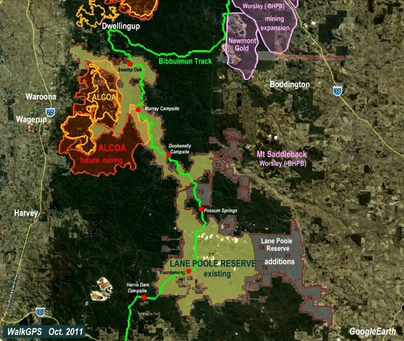
    Lane Poole Reserve – WalkGPS-GoogleEarth map image of the Reserve showing the proposed reserve additions, plus Bibbulmun Track and campsites and existing and future extent of ALCOA bauxite mining. (Also see Bauxite mining page.)

    “Lane Poole Reserve”, DBCA site. – Includes a downloadable Park Guide.

    “Travellers guide to the Parks & Reserves of Western Australia”,  Simon Nevill, 4th Edn. 2011, p.62-63 (Simon Nevill Publications) –  Includes a very brief summary of the Reserve.

    Trivia: What does the “Form” or “Formation” in Coffs Form. or South Junction Formation mean? – A ‘formation’ (or ‘form.’) comprises the top of embankments and base of cuttings on which a railway or tramway track was laid to take timber to a local mill. The railways themselves have largely disappeared leaving the ‘forms’ as reminders of the earlier logging days.  They are common in the southwest forests and have often been later converted for 4WD/forestry vehicle use (and partly for easy, levelled walking tracks!).

    Other map availability

    South West WA 25K Scale Topo Maps”, Greg Harewood & Landgate,  2015.  – Digital raster; ECW format on 16GB USB. See tiles #285-2132-III-NE and #286-2132-III-NW for relevant map coverage.

Back to top