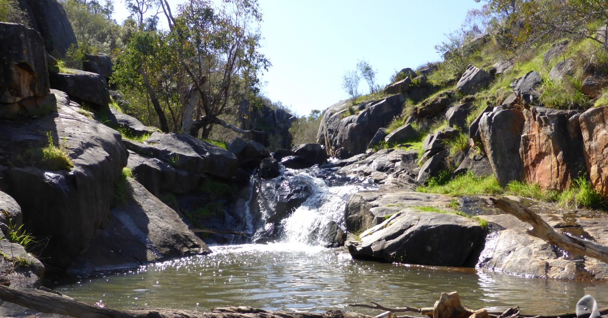
Start (waypoint ‘START’) from the car park at the John Herington Memorial Picnic Area off Coulston Road (or see Alternative Start point below for a nearby, more secluded carpark). Follow the vehicle track via ‘1’ and ‘2’ and continue to ‘3’ on the floor of the Mountain Quarry (often incorrectly called the Boya Quarry). In good weather on a Sunday there will usually be rock climbers and abseilers in action here, tackling the impressive surrounding rock faces. After admiring their feats and/or the interesting geology retrace your steps to ‘4’ and follow an initial narrow foot-track that heads west from behind the toilet block there. The track soon widens onto an old vehicle track. Cross a mountain bike track at ‘5’. Another track joins from the left at ‘6’ and the track starts climbing around the SW slopes of Greenmount Hill. At ‘7’ locate and follow a minor, partly overgrown sidetrack on the right which heads upslope beneath the N-S oriented power transmission lines. Rejoin the main track at ‘8’. Continue N-ward for a short distance below the power lines to reach an old track on the right at ‘9’ where a few boulders block access to vehicles. Follow the rough track E-ward up the steep gully through forest. At ‘9-1’, optionally veer off-track to the right a short distance to locate minor mountain bike track/s which lead up the hillside and make the steep climb a little easier. At ‘9-2′ veer left to return to the main track at ’10’. (Alternatively, stay on the main track at ‘9-1′ to head directly to ’10’.) Cross the track N-ward at ’10’ and follow another old track to a track junction at ’11’. Follow this good track through forest along the hillside. Cross a vehicle track at ’12’ and continue past the tall communications tower at ’13’. (Optionally, the nearby Greenmount Hill lookout and parking area at the end of Padbury Road can be reached by a short return trip via a short (less than 50m) foot-track that passes through bushland to the east of the comms. tower.) Follow a mountain bike trail N-ward downslope through heathland to a junction at ’14’. Turn left and follow the track W-ward down the hillside, passing into some very nice open wandoo woodland. Turn right at ’15’ and descend N-ward down a small valley through the open wandoo. Veer right at ’16’ to follow a mountain bike trail and other minor tracks around this northern slope via ’17’ and ’17-1′, passing through a widespread infestation of Watsonia weed. Veer left at ’18’ and descend to a stream course which is a small tributary of Convict Creek. Follow this gully upstream, crossing a dolerite rock outcrop (with small waterfall) and then a firebreak track at ’19-1′. Continue along the left bank of the stream course to ’20’, then cross the stream to then re-cross the track at ’21’. Follow vague tracks through the heathland to meet a mountain bike track at ’21-1′. Veer left and on reaching a track T-junction at ’22’, turn right and follow a small gully S-ward upslope through wandoo woodland via ’22-1′. The track veers right at ’23’ and reaches Padbury Road (sealed) at ’25’. Cross the road and turn left onto an old vehicle track paralleling the road. Pass a mountain bike track entry at ’25-1′, then turn right at ’26’ to follow another mountain bike track S-ward through jarrah forest via ’27’. The track turns W-ward at ’28’. At ’29’ veer right to head W-ward via ’29-1′ through heathland to reach another track at ’30’. From here there are good views across the Darling Scarp through forest toward Perth city. (An optional short, 70m diversion off the route to a nearby granite outcrop visible to the west is a very nice spot for a rest stop.) Head mostly S-ward along the track via ’31’ and ’31-1′. Veer left at a track junction at ’32’ and then turn right at ’33’ onto a side track which heads initially downslope before crossing a vehicle track at ’35’. The minor foot-track/mountain bike track turns S-ward at ’36’ and soon crosses a rocky area toward the end of a ridge line. At ’37’ veer right a few metres below the top of a sloping outcrop descend S-ward quite steeply down a ‘gutter’ in the outcrop and then through a patch of forest to reach a firebreak track at ’38’. Turn right to follow the track for less than 25m, then turn left at ’39’ to follow a vague foot-track through heathland to cross the small Darlington Brook at ’40’ and reach Coulston Road at ’41’. (Or see Option 1 below for a shorter walk option after ’39’.) Cross the road to follow a vague track at ’42’. Cross the nearby Railway Reserve Heritage Trail and follow a minor track to cross an unsealed extension of Pine Terrace at ’45’. Veer left onto an old vehicle track which climbs up the hillside. At ’46’ veer right and head off-track upslope via ’47’ through heathland and open forest to reach a vehicle track near a junction close to the hill top at ’48’. The forest and heathland south of the hilltop has been recently burned (in 2019). Cross the track onto a side vehicle track. A “Danger” sign here warns not to proceed down the vehicle track (due to risks associated with the Hudman Quarries below; See also Alerts/Issues on this page). Do not follow the road but a mountain bike track just after the sign leads safely via ’49’, initially E-ward and then SSE-ward down the edge of a rocky ridge, roughly via ’50’, ’50-1′ and ’51’. At ’52’ the track veers E-ward and reaches a rough vehicle track at ’53’. Turn right to follow the track downslope to meet a better track at ’54’. Turn right and soon reach the entry to one of the quarries at ’55’. Cross the quarry floor to about ’56’ for a good view of the rugged rock faces. Return via ’54’ and continue down the vehicle track to a sidetrack at ’57’. Follow the track downslope to cross Hudman Road (unsealed section) at ’58’. Follow a mountain bike track SE-ward via ’59’ to cross a water course at ’60’. The track meets a vehicle track which passes via ’61’ a power plant on the left. Leave the track to cross Victor Road (sealed) at ’62’. Then head off-track through heathland via’ 62-1′. Reach an old, very overgrown vehicle track at ’62-2′ and follow SE-ward to meet a vehicle track at ’63’. Veer right to nearby ’64’, then head S-ward initially along the edge of a large granite slab outcrop. (Note: Along this outcrop look for the unusual sight of 2 ‘observing pillars’ and a series of 21 stainless steel pins set into the rock. These form Landgate’s Boya barcoded staff calibration range. Surveyor’s can have their barcoded surveying staves re-calibrated here every few years to obtain a current certificate confirming accuracy.) Veer left (SSE-ward) at ’65’ and climb gently through very open heathland to cross close to a hilltop area at ’65-1′. Descend across patchy outcrops to ’66’ from where there are good views across Nyaania Creek valley to the opposite slope, to be traversed later in the walk. Turn right, initially along slope through heathland to ’66-1′ and then veer left to head SSW-ward quite steeply downslope following a now-narrow, partly overgrown old track through heathland and then shrubland via ’66-2′ and ’66-3′. Veer left (S-ward) at ’67’ to descend a steep grassy slope and reach a good foot-track along Nyaania Creek at ’68’. Turn left to follow the track upstream, initially along the north bank. Soon reach a large pool and waterfall surrounded by a rocky ‘ampitheatre’. This is a great spot to take a good break and soak up the ambience! Then follow the right hand bank of the creek, passing more small cascades and falls. The track re-crosses to the left bank at about’70; then back to the right hand bank at ’71’. It then stays on the right bank for a final 300m, passing under power transmission lines near big boulders at ’72’. Reach a granite slab and area of very small cascades/rapids at ’73’. This is another pleasant spot for a rest before the final phase of the walk. Leave the Creek by turning sharp right to head S-ward via ’74’ up the western edge of a rocky ridge. Turn right (SW) onto a vehicle track beneath power transmission lines at ’76’. Leave the track at ’77’ to continue along slope and off-track beyond a tower. (OR see below, an option to bypass this next off-track section below, after ’77’). Cross a granite outcrop which gives good views back across the valley, including to part of the route already walked. Continue mainly along slope via ’78’and ’78-1′. Veer right, downslope through a patch of heathland at ’79’ to reach a more open area with views across Helena Valley at ’79-1′. Cross a mountain bike track and reach the edge of an outcrop at ’80’. Turn right to head a short distance downslope, then left around the base of the outcrop to join a mountain bike trail before ’81’. Follow the trail down the ridge and hillside via ’82’ to reach Victor Road at ’83’ near Nyaania Creek (OR see alternative partial Victor Rd bypass option below, after ’82-ALT’). Head north along Victor Road (sealed) for 500m, initially passing at ’83-1′ the entry to the Nyaania Creek foot-track, and the junction with Clayton Road at ’84’. At ’85’ veer left to head off-track, past a large slab outcrop and through forest, soon reaching a vehicle track at ’85-1′. Turn left to follow the vehicle track across a stream course, then veer right at ’86’ to follow a mountain bike track upslope to rejoin the vehicle track at ’87’. Follow the track to ’88’ and then NW-ward along the edge of former farmland for 700m. When the track veers right at ’89’ continue NW-ward on a foot-track. Pass around a gate at ’90’ and turn right, passing the corner of Approach Road and Hudman Road (sealed) to walk through a small carpark area at ’91’. Veer left to follow a track which connects with the Railway Reserve Heritage Trail at ’92’. Veer left to follow the Trail across Coulston Road and back to the Start point.
Alternative Start point – The small carpark area at ’91’ at the corner of Approach Road and Hudman Road may be preferred as a more secluded and potentially more secure parking area, and/or if opting to walk only the ‘Southern Circuit’ (see Option 2 below). The carpark at the main Start point may be too full on the day of a walk, or you may have fears for car security at that more publicly exposed location. (Note that cars have been broken into at this carpark, so don’t leave any valuables in your car.) The alternative location is only 500m via Hudman Road from the main location, so the choice of parking location can be made at the time of the walk.
Alternative bypass of the off-track section south of Nyaania Creek – Some walkers will prefer to avoid the 400m of off-track walking between waypoints ’77’ and ’81’. That section can be easily bypassed by continuing on the vehicle track past ’77’. The track climbs SE-ward. When it reaches the hilltop, turn left onto a side track on the right. Less than 50m along that vehicle track turn right to follow a mountain bike track westward downslope for about 400m to rejoin the described route at waypoint ’81’. This option adds less than 500m to the total walk distance.
Alternative partial Victor Road bypass in south – Most of the ~500m of the section along Victor Rd can be bypassed by a more adventurous, partly off-track section as follows: Before reaching waypoint ’82’ while descending the mountain bike track in the south, turn right, off-track at ’82-ALT’ initially along slope through heath/shrubland, then turn left at ’83-ALT’ to descend NW-ward past a sizeable outcrop on the right to cross Nyaania Creek (an easy short boulder hop). Continue up the northern bank to cross the nearby foot-track at ’83-1ALT’ onto an old, vague track which climbs gently NNW-ward through tall shrubland. Turn left at ’83-2ALT’ to descend to meet Victor Rd and rejoin the main route less than 100m from the junction with Clayton Rd at ’84’. This alternative section bypasses about half (250m) of the Victor Rd walking.
Shorter walk options: This walk can easily be separated into two good, shorter walks, each of about 6km, as follows:
Option 1: Northern Circuit – Greenmount National Park – Includes a short linking section just north of Darlington Brook to return to the start point. Follow the described route to ’39’, then instead of turning left to ’40’, continue along the firebreak track via ’40-ALT’. Turn left at ’41-ALT’ the head W-ward off-track via ’42-ALT’, ’43-ALT’, ’44-ALT’, ’45-ALT’ and ’46-ALT’ to rejoin the vehicle track from Mountain Quarry at ’47-ALT’. The short, off-track section is less than 300m long, but passes some interesting boulders and outcrops. Optionally, the off-track section can be bypassed after ’41-ALT’ by staying on the firebreak track until it also meets the Mountain Quarry track.
Option 2: Southern circuit – Helena Valley north (including Nyaania Creek) – South of Coulston Road, using the alternative start point (off Hudman Road) and initially heading eastward along the Railway Reserve Heritage Trail between ’92’ and ’44’ to bypass the northern Greenmount area. Then follow the described route from ’44’ to ’91’.