Kitty’s Gorge – Serpentine Falls Walk overview

The longer distance, rugged terrain and off-track sections make this one of the more challenging WalkGPS routes, suitable for the more experienced walkers though it can easily be shortened for others. The walk takes you into some more remote, seldom-visited areas of Serpentine National Park while still including most of the popular, established Kitty’s Gorge Trail. The cascades and waterfalls along Gooralong Brook are not to be missed after good winter rainfall. And a visit to Serpentine Falls itself is a bonus at the end of the walk.

  • Main features / Highlights

    This is a rewarding, more challenging, longer walk suitable for experienced bushwalkers. The walk takes in most of the established Kitty’s Gorge trail (Gooralong Brook) and some of the surrounding hill tops within the Serpentine National Park and Gooralong Park. There is a lot of variety in scenery and terrain, and splendid views from hills above the Gorge and from south of Serpentine Falls reward some steady climbs. The waterfalls and cascades are impressive after winter rains. The sections of road-walking are well broken by the off-track sections.

    The described route can be varied to decrease the walk distance. (See Route notes for details): A shorter (~15.5km) option bypasses the section of the described route east of Gooralong Brook without sacrificing any of the interesting walking in the seldom-visited areas to the south of the Serpentine River valley. Shorter, easier walk options for inexperienced walkers and/or warmer weather include Stacey’s Trail and part of the Kittys Gorge Trail.

    Also see WalkGPS video “Serpentine Falls – Kittys Gorge, Western Australia” for impressions of the walk area.

  • Route notes

    Head south from the carpark (at waypoint ‘START’) and past the toilet block at ‘1’ to meet an unsealed road at ‘2’. Follow the road southward up the narrow side gully. After the road crosses the stream to the east bank at ‘3’, take the right-hand, southward fork. The road then continues climbing along the gully,  initially steeply, before re-crossing the stream at ‘4’. At ‘5’ veer left off-track and navigate up an around the hillside through the forest via ‘6’, ‘6-1’ and ‘7’. Scramble up onto an outcrop at ‘7-1’ and cross the main gully again at ‘8’ at a rock ledge above a nice cascade when the stream is flowing. Walk upstream for only 30m along the sloping north bank through heath to ‘8-1’, then turn left to head upslope on a granite outcrop. At ‘9’ veer left and pick an easy route through a belt of shrubland to reach a rock promontory at ‘9-1’. Descend a little to ‘9-2′, then veer right (NNW) to cross a small gully on the north side of the outcrop and head up the hillside through mostly open forest to reach a flatter section after ’10’. Continue mostly along slope via ‘10-1’, ‘11’ and ‘11-1’, across some very open ground with patches of heath and balgas, gaining good views to the NW. Take in the view westward across the side valley to Baldwins Bluff (the rock slopes are hidden from here) and down the lower Serpentine River valley and across the Swan Coastal Plain. Veer right (NE) on a rock slab at ’12’ and pass a roughly constructed rock seat with a view at ‘12-1’. Cross the crest of a gentle spur ridge through a patch of wandoo woodland and reach a dark (dolerite) rock slab at ‘13’ near the head of a gully which drains steeply northward into the main valley. Veer ESE up the flank of the gully, then eastward at ‘14’ through open jarrah forest to meet a vehicle track at ‘15’ on the crest of a ridge. Turn right to follow the track  eastward. When it soon (in less than 100m) bends to the right at ‘15-1’ continue off-track through forest along the laterite-capped ridge to meet a vehicle track along the edge of cleared land (a former farm). Turn left to follow the track around the edge of the open land to reach a communications tower at ‘17’. Turn left (northward) to follow a track to the north side of the tower. Then descend off-track through forest across the short, steepish laterite escarpment to ‘18’. Emerge from the forest onto an open rocky slope with scattered large balgas and great views across the main valley and up Gooralong Brook valley.   This is a good spot for a morning rest stop (though no shelter if wet weather).  Walk along slope via ‘18-1’ then descend NE-ward via ‘18-2’ and ‘18-3’ down the steepening slope. At ‘19’ reach a rocky promontory above the steep and rocky valley slope with a view down to the historic Spencers Cottage near the Serpentine River and northward up the Gooralong Brook valley. At ‘19-1’ cross  fairly open ground on the crest of a gentle, north-plunging spur ridge, then descend steeply (via ‘19-2’) to reach a former farm road at ’20’ on the SW flank of Carralong Brook valley. Turn left to follow the road down the hill to a T-junction with a road at ’21’. Turn right (northward). The road here runs within 50m of the east bank of the Serpentine River. Soon pass within 100m of Spencer’s Cottage at ‘21-1’. Soon after the cottage veer left off the road to cross the Serpentine River by a small bridge at ’22’ (and note the nearby historic wooden bridge immediately upstream). Then follow another dirt road (Selkirk Road) northward, skirting a strip of farmland above the western bank of Gooralong Brook. After about 200m, at ‘22-1’, take a short, optional  diversion down to the Brook to ’22-2′ where a waterfall flows well after good rainfall. Return to the road (at ‘22-3’) then after only a further 100m veer to the right, off the road, across a grassed area to follow the well-trodden foot-track (Kitty’s Gorge Trail) north along the Brook. After about a further 500m (at ‘24’) the trail crosses a side gully and soon starts to climb. The Brook below drops 25-30m over granite rocks along the gully, over a distance of about 170m, and can be seen to the right cascading over granite outcrops; Very impressive after winter rain! Several optional short diversions to the right of the trail at ‘24-1’, ‘24-2’, ‘24-3’, ‘24-4’ to viewing points or down short sidetracks, provide better, worthwhile views of the cascades if the Brook is flowing strongly. Pass close by another good waterfall at ‘25’ (‘Little Wave Rock’; WalkGPS informal name).  The trail then flattens out again. Soon after crossing a vehicle track (at ‘26’; with an optional Brook crossing point just to the right) reach a sidetrack on the right at ‘27’. Follow this across a footbridge over the Brook below a flow-monitoring weir. (Or see Option 1 below for a short-cut to reduce the walk distance).  After crossing the Brook follow the road quite steeply uphill via’ 28’ approx. SSW.  After ‘28-1’ the slope soon eases and the the track veers SW, reaching the crest of a ridge at ‘29’. It then curves tightly eastward up the flank of the ridge and at ‘30’ turns northward, soon reaching a foot-track on the left at ‘31’, which is the continuation of Kitty’s Gorge Trail. Follow the foot-track around the steep SE flank of Gooralong Brook  valley via ‘31-1’, ‘31-2’, ‘31-3’. There are some good views west across the valley and to the coastal plain from a couple of large rock outcrops, which also offer nice options for a lunch stop. (This is about the halfway point on the walk.) The foot-track veers eastward to meet a vehicle track at ‘32.  Head NE along the road around  the top of the hillside. At ‘32-1’ the road veers north and soon begins descending. When the road veers right at ‘33’, continue downslope off-track to soon meet another vehicle track at ‘33-1’. Follow this road NNW down the spur ridge to a junction at ‘34’, passing a pine plantation on the right which lay within the former Gooralong camping ground. Pass the entry to the Kitty’s Gorge Trail on the left and follow the road to the left (not straight ahead) to cross Gooralong Brook at ‘35’.  You now have a short, steep climb (about 30m vertical gain) up the vehicle track. At ‘36’ veer left to head WSW  up through the forest. Cross a gully at ‘36-1’ then climb SW-ward to join at ‘37’ an old forestry road which runs SW and then west around the flatter margins of the hill top via ‘37-1’. After ‘37-2’ the track descends over a distance of 200m and then crosses the head of a gully. At ‘38’ veer left off-track through open forest, soon crossing a small outcrop at ‘38-1’. Then head southward down a narrowing ridge and cross a rocky promontory at ‘38-2’. At ‘39’ veer sharp right (west) and descend briefly to cross a narrow, steep-sided gully at ‘40’.  (In spring, keep a look out for the White Spider Orchid along this section of the walk.) Continue roughly southward up slope to ‘41’ (from where there is a view SSE down the gully and across Gooralong Brook and Serpentine River valleys.) and then descend via ‘41-1’ to another narrow, rocky ridge at ‘42’ with more views. Pick a way downslope via ‘42-1’ and ‘42-2’ through patches of denser heath, following animal tracks wherever possible to avoids scratches. Cross a rocky stream course at ‘42-3’ above a small waterfall. Then continue southward, along slope to soon meet Selkirk Road (rough, unsealed) at ‘43’. Turn left to follow the road back down to Gooralong Brook and (via ‘44’) re-cross Serpentine River and pass Spencer’s Cottage again, retracing your steps of the outbound part of the walk. Follow the vehicle track/road around the southern bank of the Serpentine River to ‘46’. Then turn right at the marked Kittys Gorge Trail at ‘46’ and follow the foot-track to ‘47’ which is close to the river bank. Before leaving the river bank to follow the foot-track up slope to ‘48’ it’s worthwhile continuing down the riverside to reach at ‘47-1’ a swimming hole formeed by an old concrete dam wall across the Serpentine River. On a hot day this is a great place for a cool dip near the end of the walk!) Then either back-track via ’47’ to reach ‘48’ or continue along the south bank to follow an alternative foot-track upslope via ‘47-2’. Rejoin the road at ‘48’ and follow it westward for 200m to ‘50’ where a track on the right leads you steeply downhill along the north side of the water pipeline. Then cross the River from ‘51’ to ‘52’ via the pipeline pedestrian bridge. It’s less than 200m back to the start point from here. But if you haven’t previously visited Serpentine Falls make sure you turn right at ‘52’ to make the short walk (200m) to the Falls viewing area at ‘52-1’. From ‘52’ head westward down the road to cross the bridge across the Serpentine River (at ‘53’) to get back to the Start point at the carpark.

    Option 1, Shorter walk distance  (via short cut ’27’ to ’34’):  If a shorter walk distance is preferred, you can bypass the section of the route on the east side of Gooralong Brook. That is easily achieved by continuing northward along the Gorge directly from waypoint ‘27’ to ‘34’ instead of crossing at ‘27’ as per the described WalkGPS walk route. That simple option reduces the total walk distance by 2.6km to about 15.5km without sacrificing any of the interesting walking in the seldom-visited areas to the south of the Serpentine River valley.

    Additional options, Existing trailsShorter walk options (mainly using part of Kitty’s Gorge Trail and Stacey’s Trail) which exclude the southern loop to Serpentine Falls are more suitable for inexperienced walkers and/or warmer weather when the full walk will not be comfortably enjoyable. Published maps for some of the local trails (including Stacey’s and Kitty’s Gorge) are also available online from the Jarrahdale Heritage Society (see “Other Info.” on this page).  Stacey’s Trail is a 1.7km loop between Jarrahdale Cemetery (on Atkins Street) and Kitty’s Gorge Trail. This passes through a small area of beautiful virgin jarrah forest. It can easily be added as a variation to the WalkGPS walk route on this page, especially if you prefer to start from the Cemetery car park at the Jarrahdale end and leave out the southern loop of the route (south of Spencer’s mud cottage).

  • Access / Directions

    To reach parking spot at Serpentine Falls carpark, follow Kwinana Freeway south, then Mundijong Road east to South Western Highway. Then south on Highway to marked road on left to Serpentine National Park and Serpentine Falls.  DBCA park entry fee applies. Park in the carpark on right hand side closest to the bridge across Sepentine River. There are public toilets and picnic area nearby.

    Alternative starting point:  Potential alternative access is via Stacey’s Trail at the northern end of the walk route near Jarrahdale township. The Gooralong Park picnic area (within Serpentine National Park), owned by the Department of Water and managed by DBCA, is closed to vehicles has no toilet facilities. No camping is allowed.

    Google Map

  • Nearest campsite/s

    N/A.  No camping permitted.

  • Escape route/s

    In north, from Gooralong Park by road about 2.5km to Jarrahdale Road and Jarrahdale township.

    In west, about 2.5km via Selkirk Road to South Western Hwy.

    In east, Kittys Gorge Road to Jarrahdale Road.

    In south, a short distance to Scrivener Road and then west about 2.5km to South Western Hwy.

  • Other Info.

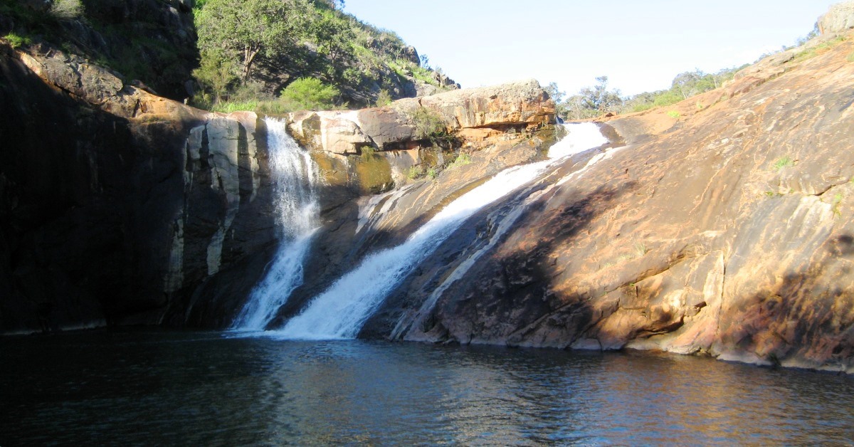
    “Baldwins Bluff Nature Track”,  DBCA site. – A 6km on-track return walk to a prominent ridge just SW of Serpentine Falls, with good views across the Falls and up the valley.

    “Kitty’s Gorge, Serpentine NP, Jarrahdale”Trails WA site. – For info, specifically on the 16km return Kitty’s Gorge Walk Trail.

    “Register of Heritage Places – Assessment Documentation – Spencer’s Cottage”, Heritage Council of W.A., ca.1994.   –  This contains an excellent summary of the history of this colonial homestead of Joshua Spencer and his descendants who had a long association of around 115 years with the ‘Carralong’ property beginning in 1860. The cottage dates from that time and was entered on the Register of Heritage Places in 1994.

    “Serpentine Falls – Kittys Gorge, Western Australia” , WalkGPS video – Impressions from the walk area.

    “Serpentine National Park”DBCA site. – Includes a downloadable Park Guide and Flora & Fauna Guide.

    Serpentine National Park Management Plan 2000-2009, CALM, 2000 – The Plan has summaries of the flora & fauna, geology, history, past park plans, etc.

    “Travellers guide to the Parks & Reserves of Western Australia”,  Simon Nevill, 4th Edn. 2011, pp. 52-53 (Simon Nevill Publications), also includes a  brief summary of Serpentine National Park.

    “Walks and Parks of Jarrahdale”, Jarrahdale Heritage Society site. – For downloadable trails maps of established trails in the area.

    Weed control –  Attempts have been made to control, if not eradicate, serious weed infestations along the section of Gooralong Brook that runs through the former recreation area in the north. Further downstream large sections of the Brook remain severely choked  by four of the worst invasive weeds in the region:  Arum lilies (Zantedeschia aethiopica), Blackberry (Rubus fruticosus), Narrow-Leaf Cotton Bush (or Swan Plant; Gomphocarpus fruticosus) and Watsonia spp.  The Cotton Bush has also intensively invaded the former farmland around Spencers’ mud cottage along the walk route and attracts large numbers of Wanderer (Monarch) butterflies (Danaus plexippus) to the area as the larvae feed on the weed (but don’t control it).

    Watsonia also invades many other areas along the western edge of the Darling Range, especially around the water courses that cut the Darling Scarp. A selective herbicide, 2-2DPA (‘Dalapon’), is now being used to destroy the weed, with encouraging results so far, including re-emergence of native heathland plants. Efforts by community groups to locally control this highly invasive weed elsewhere along the Darling Scarp, and at Piesse Brook, also appear to have had some local success.

    Other map availability

    South West WA 25K Scale Topo Maps”, Greg Harewood & Landgate,  2015. – Digital raster; ECW format on 16GB USB. See tiles  # 302-2133-III-NW  and # 304-2133-III-SW for relevant map coverage.

Back to top