The times they are a-changin’
(A shortened version of this post on the impact of the digital age on printed maps was previously published in “WILD” Magazine, issue 147, May-Jun 2015 with alternative title “Charting the future of bushwalking”.)
_____________
A WILD website opinion piece(1) by editor Campbell Phillips (reproduced in issue 146, Mar-Apr 2015) highlighted yet another impact of the digital age and globalization; whether we are Aussie bushwalkers or Kiwi trampers, it seems we’ll all eventually be linguistically homogenized into universally vanilla ‘hikers’, like it or not.
That reminded me about the progressive impact also of the digital age on the folded paper maps that most bushwalkers – even ‘hikers’ – so cherish. Rachel Hewitt of The Guardian wrote in April 2014 of “The end of the road for Ordnance Survey?” (2). As Britain’s national mapping agency, the Ordnance Survey (OS) has been synonymous with paper maps since the publication of its first map in 1801. But – quoting from Hewitt: “.. sales of paper maps decline year-on-year, and usage of digital apps and devices rises; there is a sea change taking place in the way we consume and use geographical information. Could this mark the end of the map, and if so, should we be worried?”
Not just in Britain, but elsewhere around the globe, including here in Australia – such as with our Landgate agency in WA – a major shift has occurred over the past decade, away from producing paper maps to instead maintaining huge digital databases of geographical information. Users can now download data from the databases to compile their own ‘custom’ maps (or order a custom print) that will be right-up-to-date and have just the information they want displayed. The OS has been developing smartphone and tablet apps to equip hikers and cyclists with the very latest digital info that they can download and display in map form for free in place of paper maps.
 But convenient as hand-held devices might be, the small screen sizes and limited battery life of smartphones, and less so GPS units, can be a handicap when displaying maps and navigating. So it’s no surprise that paper maps continue to be more popular in Britain than their digital equivalents. The OS still has some commitment to maintaining a series of national paper maps.
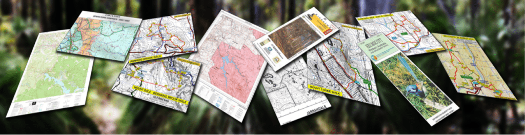
Here in WA good quality printed maps suitable for bushwalkers have become a very endangered species! The older 1:50,000 scale hard copy Forest Dept/CALM map series, were much-used by bushwalkers; even the B&W prints that replaced some of the original colour maps when they had run out years ago. Those old map sheets have now been superceded by DBCA’s (previously DBCA) Conservation Operations Graphic (COG) map series. The COG maps are updated from the digital database each year, but they are only printed on demand. They may be the most up-to-date maps, but they don’t have the same printed map quality nor the easy readability that bushwalkers enjoyed with the old maps (hopefully feedback has sparked an improvement!) A folded map series is still specially produced to cover WA’s 1000 km-long Bibbulmun Track, but those maps aren’t much use for more general bushwalking purposes partly due to their small scale.
In her article Hewitt noted that “William Wordsworth wrote of “dreaming o’er the map”: does anyone dream over a satnav?” But whether we like it or not, digital mapping databases and GPS devices are here to stay. They have made bushwalking more accessible for many, and we should all welcome that. The downside is that it’s all too easy now for almost anyone to download GPS waypoints and ‘track’ files (including those from this website!) and successfully but slavishly follow a GPS route without even a glance at a map. But what may be missed is the fun and creativity of first visualizing and planning a possible walk route initially on a map; then testing and refining that imagined route with a ‘recce’ or two; before perhaps finally leading it as a group walk, one that will be new and interesting for participants and especially satisfying for the leader.
These days we can still dream over digital topo maps and Google Earth satellite imagery on our large computer screens. And there’s no reason whatever that we can’t still plan recces for interesting new walks using similar imagination to walk leaders in the past. In fact in many respects it’s easier, provided leaders take a small amount of time to familiarize with the necessary computer tools, online facilities, and resources, most of which don’t require any special computing proficiency to locate and use. We can also get a more-or-less matchbox-sized map view on our GPS unit or smartphone. And very light-weight flexible tablets offering larger screens may also soon be with us.
But when we’re actually out on a walk, and even if we’re using GPS, there’s nothing yet to compete with opening up that printed map sheet to get a real feel for where we are in the broader landscape and so make us more truly aware of, and engaged with, our environment. Here’s to hoping such maps do survive a while longer in this unsympathetic digital world!
References
- “Is ‘bushwalking’ dying? Our brave new world of adventure” – Campbell Phillips, WILD website, Opinion, 5 Feb. 2015.
- “The end of the road for Ordnance Survey?” – Rachel Hewitt, The Guardian, Science & nature, 19 April 2014.
I have just returned from the UK. Many if my friends and relatives have made 50,000 scale maps centred to cover their own favourite areas, printed on tough waterproof paper-like material.
Even the standard 50,000 and 25,000 maps ( commonly available in most Uk high street stationers) are printed on this material.
What’s more, every ‘hard’ copy you buy has a ‘scratchy’ panel on the inside of the cover. This enables a geo-referenced copy of the map to be loaded onto your smart phone. Using the ‘phones built in GPS this means I have permanent access to all my maps. This was very useful when my walk meandered off the edge of the map for a mile or so, I could leave the second map at home and use my phone.
I recently had a 25,000 printed-off of the Monadocks area at the Map and Chart shop. No blazed forestry trees marked and no rock outcrops marked, and on ordinary paper that dissolves in the rain and falls apart at the creases.
This substandard map cost me $20, whereas the Ordnance Survey 50,000 maps on super dooper plastic with geo-referenced digital copy for my ‘phone cost $16.
WA’s maps are deteriorating in quality of information and accessibility as the first world/developed countries are streaking ahead.
Seems we can only be envious of how well UK map producers are catering for smartphones and end users generally. Meanwhile I hope the walk maps on WalkGPS help fill a void for local bushwalkers; The maps provide 25k scale detail, with 5m C.I., plus outcrop areas etc, with ‘missing’ tracks I’ve added from Google Earth and other sources (but sorry, no blazed ref. tree locns.). They’re far from perfect, but are a lot more useful than most others (except the orienteeerers own local area maps). Compare my Three Mountains map with your ‘Monadnocks’ area print. WalkGPS can’t offer hard copy maps with ‘scratchy panel’, but a practical outdoors soln is to print the maps off at A4 size, then laminate and fold into pocket size, or simply seal in a plastic, snap lock bag (eg 22cmx25cm). Another fairly easy solution is to extract the walk area base map from the WalkGPS Map files provided (see Maps & GPS data page) and convert those to ‘Custom Maps’ to upload to your GPS (if a Garmin GPS user).